Local Walks
Warminster has miles of wonderful countryside ripe for exploration. Check back here regularly for our suggested Local Walks!
Wiltshire walks to download
John Harris’ takes you on a journey around Wiltshire and beyond with his ‘Walking in England’ walks. There are many free downloadable walks available for you, with distance and time for you to plan a wonderful Wiltshire Walk.
Also you may consider joining regular walking groups via the Warminster Walkers club And Get Warminster Walking
Popular walks
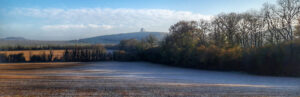
Heaven's Gate

Heavens Gate Circular is a 1.7 mile loop trail located near Warminster, that features a great forest setting and is good for all skill levels.
The trail is primarily used for hiking, walking, trail running, and nature trips. Heaven's Gate is a popular, free, place to visit, provided by Longleat, which it overlooks, and has usually ample free car parking opposite the entrance.
Quick Facts:
- Flat walk and forest
- Free parking
- Wheelchair friendly
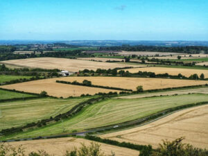
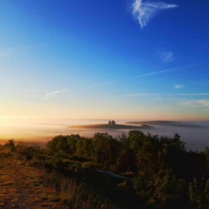
Cley Hill
 Cley Hill is a prominent hill to the west of Warminster in Wiltshire, England. Its summit has a commanding view of the Wiltshire / Somerset county boundary, at 244 metres elevation.
The land is owned by the National Trust. A 26.6-hectare (66-acre) area of chalk grassland at Cley Hill was notified as a biological Site of Special Scientific Interest in 1975.
Quick Facts:
- Distinct landmark rich in wildlife and archaeology
- Famous UFO hotspot
- Preserved by the National Trust
The National Trust have also published a detailed 9.5 mile walk around Cley Hill
Middle Hill
 This sensibly named hill is right between Battlesbury Camp and Scratchbury and is crowned by a be-treed round barrow.
Under its alternative name, Starr Hill, it was the location for many a UFO sighting during the famous Warminster UFO flap in the 1960s.
Quick Facts:
- Middle Hill is an aptly named conical chalk hill
- Summit of Middle Hill is topped with a 33 metre diameter bowl barrow
- Excellent views
Arn Hill
 Arn Hill rises to over 650 feet above sea level and its woodland was donated to the town by the Marquess of Bath in 1920.
The Wiltshire Wildlife Trust have established a nature trail around Arn Hill which passes a former lime-kiln (now in ruins) and rises above the old-fashioned sheep walks of Kidnapper's Hole. The chalkland flora, which includes orchids, attracts many insects and butterflies, while the woods are a haven for several species of birds.
Quick Facts:
- Two-mile footpath circles the golf course with distant views to Salisbury Plain.
- Its woodland was donated to the town by the Marquess of Bath in 1920
- The Wiltshire Wildlife Trust have established a nature trail
Battlesbury Hill
 Battlesbury Hill is an Iron Age hill fort dating from approximately 50BC.
It was probably a permanent settlement judging from the artefacts that have been discovered.
Quick Facts:
- Excellent hill fort with ramparts
- 208 metres high
- Easily accessible by public footpath; however, care must be taken not to stray into the military firing ranges of Salisbury Plain immediately to the northeast.
Cop Heap
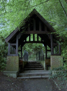 Copheap, the hill closest to Warminster, just north of the town, was purchased by the Warminster Urban District Council and soon afterwards it was agreed at a public meeting in 1947 that it should become a war memorial for the town. The purchase price was met by public subscription.
Members of the R.A. and Old Comrades associations constructed the Path of Remembrance from Copheap Lane to the base of the hill, with regimental badges being incorporated into the walls at the lower end of the path.
A lych gate at the entrance to Copheap is inscribed:
"As an everlasting tribute of pride and gratitude to the sons of Warminster who gave their lives in the great World Wars this archway was constructed and Copheap preserved for the perpetual use and enjoyment of all."
Quick Facts:
- Steep walk leads to a barrow on the top
- The uphill walk, leading though a Memorial Lych Gate
- The wood is surrounded by chalk grassland owned by the MOD
(Photo by Neil Owen 2013)
Please contact us or complete the form below if you wish to add a suggested walk to the list above.

Do you have a great walk in the local area to suggested for inclusion own our website?
Let us know and we will add it to our list! We may contact you to see if you have any supporting photographs or maps which we can attach to the walk description.